Display Field: StateAbbr
Type: Feature Layer
Geometry Type: esriGeometryPolygon
Description:
This layer shows the number of Broadband Serviceable Locations (BSLs) in a given geography by their corresponding speed tier. The speed tier is defined by speed and latency and each BSL is bucketed into one of three categories:
- Served - low-latency Fiber, Cable, Copper, or Licensed Terrestrial Fixed Wireless offering of speeds greater than or equal to 100/20 Mbps.
- Underserved - low-latency Fiber, Cable, Copper, or Terrestrial Licensed Fixed Wireless offering of speeds less than 100/20 Mbps, but greater than or equal to 25/3 Mbps.
- Unserved - all service that is not low-latency or less than 25/3 Mbps, and all Geostationary Satellite, Non-geostationary Satellite, Unlicensed Terrestrial Fixed Wireless, and Other.
Each geography is attributed with the number of low-latency Fiber, Cable, Copper, and Licensed Terrestrial Fixed Wireless offerings by speed tier (served, underserved, and unserved), including when the transmission technology is unavailable at that BSL.
Each geography also has a related table containing records summarizing all available service offerings, including provider name, transmission technology, and the number of BSLs where it’s offered. Related tables also contain the served, underserved, and unserved BSL counts, but they are purely speed-based (regardless of latency).
By default, this layer is symbolized with the total number of Underserved and Unserved BSLs, or "BEAD Eligible" locations. This will help identify areas eligible for immediate funding. The data is richly attributed and can be used to investigate all aspects of reported availability and number of serviceable locations. For instance, Areas shown as served, but where availability is overstated, and a challenge is warranted to help make funding available.
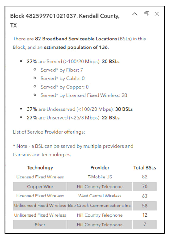
The pop-ups are configured to show the breakdown of Broadband
Serviceable Locations by speed tier. They give the total number of BSLs,
the FCC 2021 population estimate, and the percent and number of BSLs
that are Served, Underserved, and Unserved. Additionally, the popup
pulls the individual provider information from the related table to list
the total number of BSLs served (at any speed tier) in that geography.
By default, the list is filtered to exclude Geostationary Satellite and
Non-geostationary Satellite, but those numbers are available if desired.
While not included in the default pop-up, the related records do
contain the BSL speed tier breakdown.
Additional Resources:
- Broadband Deployment Accuracy and Technological Availability (DATA) Act
- FCC Broadband Data Collection
- Broadband Equity, Access, and Deployment (BEAD) Program
- The Broadband Data Collection and ArcGIS Living Atlas of the World
Copyright Text: Federal Communications Commission, Broadband Data Collection
Min. Scale: 0
Max. Scale: 0
Default Visibility: true
Max Record Count: 2000
Supported query Formats: JSON, geoJSON, PBF
Use Standardized Queries: True
Extent:
-
XMin: -19951915
YMin: -1610638
XMax: 20021886
YMax: 10597216
Spatial Reference: 102100 (3857)
Drawing Info:
- {"renderer":{"type":"simple","symbol":{"type":"esriSFS","style":"esriSFSSolid","color":[238,201,252,255],"outline":{"type":"esriSLS","style":"esriSLSSolid","color":[110,110,110,255],"width":0.7}}},"scaleSymbols":true,"transparency":0,"labelingInfo":null}
HasZ: false
HasM: false
Has Attachments: false
Has Geometry Properties: true
HTML Popup Type: esriServerHTMLPopupTypeAsHTMLText
Object ID Field: OBJECTID
Unique ID Field:
-
Name : OBJECTID
-
IsSystemMaintained : True
Global ID Field:
Type ID Field:
Fields:
- OBJECTID (type: esriFieldTypeOID, alias: OBJECTID_1, SQL Type: sqlTypeOther, length: 0, nullable: false, editable: false)
- StateAbbr (type: esriFieldTypeString, alias: State Abbreviation, SQL Type: sqlTypeOther, length: 2, nullable: true, editable: true)
- SUM_TotalPop (type: esriFieldTypeDouble, alias: SUM_TotalPop, SQL Type: sqlTypeOther, nullable: true, editable: true)
- SUM_TotalBSLs (type: esriFieldTypeDouble, alias: SUM_TotalBSLs, SQL Type: sqlTypeOther, nullable: true, editable: true)
- SUM_UnservedBSLs (type: esriFieldTypeDouble, alias: SUM_UnservedBSLs, SQL Type: sqlTypeOther, nullable: true, editable: true)
- SUM_UnderservedBSLs (type: esriFieldTypeDouble, alias: SUM_UnderservedBSLs, SQL Type: sqlTypeOther, nullable: true, editable: true)
- SUM_ServedBSLs (type: esriFieldTypeDouble, alias: SUM_ServedBSLs, SQL Type: sqlTypeOther, nullable: true, editable: true)
- SUM_ServedBSLsCopper (type: esriFieldTypeDouble, alias: SUM_ServedBSLsCopper, SQL Type: sqlTypeOther, nullable: true, editable: true)
- SUM_ServedBSLsCable (type: esriFieldTypeDouble, alias: SUM_ServedBSLsCable, SQL Type: sqlTypeOther, nullable: true, editable: true)
- SUM_ServedBSLsFiber (type: esriFieldTypeDouble, alias: SUM_ServedBSLsFiber, SQL Type: sqlTypeOther, nullable: true, editable: true)
- SUM_ServedBSLsLTFW (type: esriFieldTypeDouble, alias: SUM_ServedBSLsLTFW, SQL Type: sqlTypeOther, nullable: true, editable: true)
- SUM_ServedBSLsLBRTFW (type: esriFieldTypeDouble, alias: SUM_ServedBSLsLBRTFW, SQL Type: sqlTypeOther, nullable: true, editable: true)
- Shape__Area (type: esriFieldTypeDouble, alias: Shape__Area, SQL Type: sqlTypeDouble, nullable: true, editable: false)
- Shape__Length (type: esriFieldTypeDouble, alias: Shape__Length, SQL Type: sqlTypeDouble, nullable: true, editable: false)
Templates:
- Name: HighCostAreas_State
Description:
Drawing Tool: esriFeatureEditToolPolygon
Prototype:
- Attributes:
Is Data Versioned: false
Has Contingent Values: false
Supports Rollback On Failure Parameter: true
Last Edit Date: 9/14/2023 12:17:05 AM
Schema Last Edit Date: 9/14/2023 12:17:05 AM
Data Last Edit Date: 9/14/2023 12:17:05 AM
Supported Operations: Query Query Pivot Query Top Features Query Analytic Query Bins Generate Renderer Validate SQL Get Estimates ConvertFormat