In Dedicated Hosting: True
Preferred Host: p3eplmys2rvchkjx.svcs.arcgis.com
Service ItemId: cb67660f56de482a88255fc2b8fcdbc4
Has Versioned Data: false
Max Record Count: 1000
Supported query Formats: JSON
Supports applyEdits with GlobalIds: False
Supports Shared Templates: True
All Layers and Tables
Layers:
Description:
This layer displays the areas in the world where the Watershed and Trace Downstream tools are available, along with the data source and resolution information.
To learn more, read the developer documentation for Watershed.
To use the Watershed or Trace Downstream Geoprocessing services in ArcGIS Desktop 10.2.1 and higher, you can either connect to the Ready-to-Use Services, or create an ArcGIS Server connection.
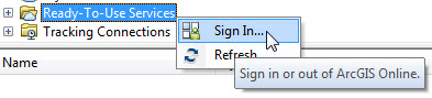
Connect to the Ready-to-Use Services by first signing in to your ArcGIS Online Organizational Account:
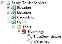
Once you are signed in, the Ready-to-Use Services will appear in the Ready-to-Use Services folder in the Catalog window:
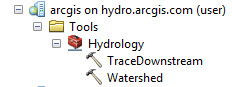
If you would like to add a direct connection to the Hydro ArcGIS Server, use this URL to connect: http://hydro.arcgis.com/arcgis/services. You will also need to provide your organizational account credentials.
ArcGIS Desktop:
ArcGIS Pro:
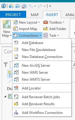
The ArcGIS help has additional information about how to do this:
- Learn how to make an ArcGIS Server Connection in ArcGIS for Desktop.
- Learn more about using geoprocessing services in ArcGIS Desktop.
This layer is part of a larger collection of elevation layers that you can use to perform a variety of mapping analysis tasks.
For more information, see the Landscape Layers group on ArcGIS Online.
Copyright Text: Esri, USGS, EPA, WWF
Spatial Reference: 102100 (3857)
Initial Extent:
-
XMin: -14816217.6956882
YMin: -598215.767656021
XMax: 16591764.6081081
YMax: 24542175.8645912
Spatial Reference: 102100 (3857)
-
XMin: -19942654.86
YMin: -7555264.3327
XMax: 20037507.0672
YMax: 17948623.3688
Spatial Reference: 102100 (3857)
Child Resources: Info SharedTemplates
Supported Operations: Query ConvertFormat Get Estimates