Service ItemId: a97c62f19eae4af58d946d1c249aabf2
Has Versioned Data: false
Max Record Count: 2000
Supported query Formats: JSON
Supports applyEdits with GlobalIds: False
Supports Shared Templates: True
All Layers and Tables
Layers:
Description:
This map was adapted from a map published by the U.S. Army Center of Military History in chapter twelve of "American Military History Volume I, The United States Army and the Forging of a Nation, 1775-1917" by Richard W. Stewart, general editor. It can be found as Map 34 on page 299, and at https://history.army.mil/books/AMH-V1/ch12.htm
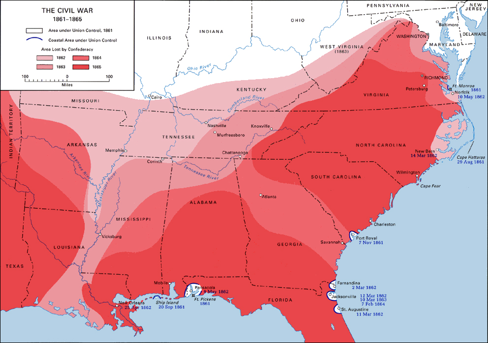
The map was georeferenced and hand digitized, using Esri's generalized US state boundary dataset as a base layer to improve drawing speed.
One notable feature of the map is how it distinctively shows Sherman's March through Georgia in 1864 and the Mississippi River campaigns.
From the text: "Viewing the war in its broadest context, a historian could fairly conclude that a determined general of the North had bested a legendary general of the South, probably the most brilliant tactician on either side, because the Union could bring to bear a decisive superiority in economic resources and manpower. Lee’s mastery of the art of warfare staved off defeat for four long years, but the outcome was never really in doubt. Grant and Lincoln held too many high cards; and during the last year of the war, the relations between the Union’s Commander in Chief and his General in Chief set an unexcelled example of civil- military coordination. This coordination was essential to prosecuting a multitheater war characterized by the slow, yet steady expansion of the area brought back under Federal control over the course of four years of struggle. (See Map 34.)"
Copyright Text: Esri, U.S. Army
Spatial Reference: 5070 (5070)
Initial Extent:
-
XMin: -2585498.48004
YMin: -63138.908084058
XMax: 2486881.99884
YMax: 3540553.68798406
Spatial Reference: 5070 (5070)
-
XMin: -2354935.731
YMin: 311822.4337
XMax: 2256319.2498
YMax: 3165592.3462
Spatial Reference: 5070 (5070)
Child Resources: Info SharedTemplates
Supported Operations: Query ConvertFormat Get Estimates